A campground on Snæfellsnes, and twenty-three seconds of birds defending it
Every figure on this site is built on this page, so it is written to be argued with: each row says what was observed, what was inferred from something else, and what nobody has established yet.
Ten passes in 22.67 seconds, one every 2.36

The frame at 19.55 s, cropped at native resolution: the loudest moment in the recording and the one where the bird is largest. Bill uniformly red with no black tip, cap full to below the eye, narrow dark trailing edge on the outer primaries, long tail streamers. That is a layman's reading of the marks, not an identification. It is the frame to put in front of someone who can rule.
What is measurable in it
Ten passes in 22.67 seconds, one every 2.36 s, measured off the audio envelope rather than counted by eye. Each pass is a discrete alarm call with near-silence between. The three closest are at 7.25 s, 14.25 s and 19.5 s. 19.5 s is both the loudest moment and the frame where the bird is largest.
The published copy is encoded -map_metadata -1. The master is geotagged; the web copy is not,
on purpose: the coordinate is the approximate position of an active colony.
Seven things we hold, and what each one can carry
| Evidence | What it shows | Standing |
|---|---|---|
| The recording 12 Aug 2026, 18:19 UTC |
Birds over the tent rows, hillside and sea behind, overcast. Ten defensive passes in 22.67 s. | observed Species unconfirmed |
| Bill and cap detail frame at 19.55 s |
Cropped at native resolution: bill, cap, primaries, tail streamers. Cut for the species question, and it happens to be the best frame in the file. | inferred The frame to put in front of someone who can rule |
| Moss-covered lava, with the build behind it 12 Aug 2026, 14:59 UTC |
Moss and lichen over broken lava in the foreground; the main stage structure, white tent rows and crew in hi-vis on the horizon. Geotagged, and it falls inside the published arena polygon, 177 m from the nearest camping zone. | observed Whether the community is protected or slow-recovering is a question for someone who can identify it |
| The promoter's published plans retrieved 14 Aug 2026 |
Arena boundary, stages and gates; and 17 colour-coded camping zones either side of road 574. Published on the festival's own companion app. | observed Captured because a published layout is the kind of page that changes after an event |
| The 18-polygon footprint GeoJSON + GPX, WGS84 |
Arena 4.26 ha, camping and ancillary 15.08 ha, total 19.34 ha, georeferenced off the plans against satellite imagery to an RMS of about 0.8 m. | inferred ±10%. This is the footprint the promoter published, not the area disturbed |
| The mowing date, and the instruction | When the ground was cut and raked flat, and under whose authority. | unverified Requested. See what we asked for |
| GPS track of disturbed ground | Where real disturbance departs from the published line: walked, not drawn. | unverified · expiring Collectable only while the ground still shows it |
observed inferred unverified. Did we see it? This is the provenance tiering, and it applies to the evidence on this page: what was personally observed, what was derived from something else, what nobody has established. Anything not personally observed moves down a tier, and the whole argument of this site is that the accurate version of a claim beats the maximal one.
primary official secondary unverified. How good is the source? This is the register's tiering, used site-wide on legal, statistical and published claims, with the same three words the benchmark file already uses. It is not a new vocabulary and must not become one.
Two checks that were withheld and then tested, rather than used. The moss photograph lands inside the arena polygon. The video lands 35 m from the edge of an "easy camping" zone: agreement, not a discrepancy, given the four decimal places the file carries. Neither could have come out this way if the georeferencing were wrong, and neither was an input to it.
Eighteen polygons, 19.34 hectares, drawn to scale
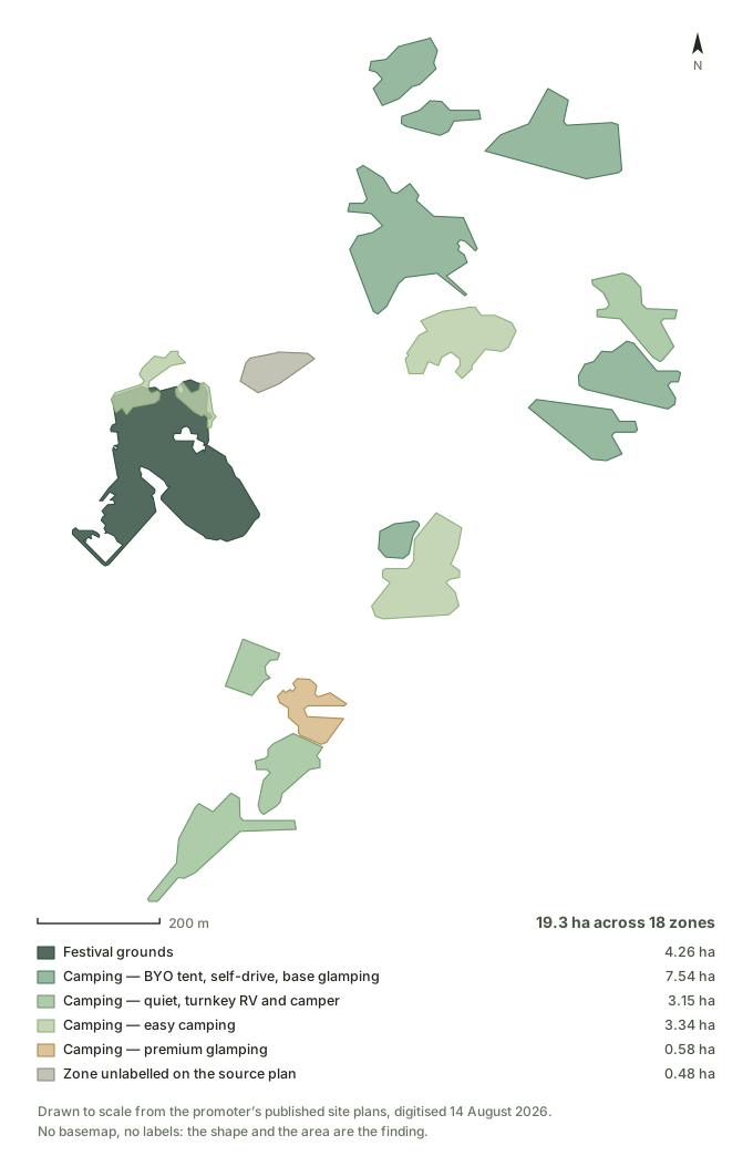
Say "the footprint the promoter published", never "the area disturbed." Nothing in this polygon was walked. Zones drawn on a plan are not always fully used, and haul routes, staging, overflow parking and spill past a marked edge appear on no plan at all. Actual disturbance will differ in both directions.
Vertex accuracy is roughly ±5–15 m, dominated by the width of the drawn boundary on the source maps rather than by the fit. That is why this page says about 19 hectares in prose and keeps 19.34 to the table, where the method sits next to it.
Method, source extents and per-polygon areas: evidence/README.md
Moss, lichen and lava in the foreground; the stage on the skyline
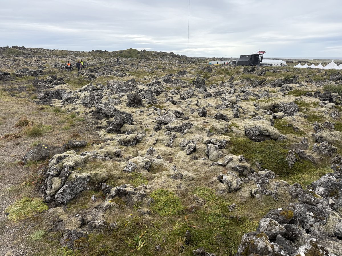
Photographed on the ground at 14:59 UTC on 12 August, three hours and twenty minutes before the recording, and about 290 m south and 560 m west of it, so the two together bracket a piece of ground rather than pinning one spot.
Why this photograph carries more than it looks like it does. Every other piece of evidence here shows one thing: the birds, or the plan, or the polygon. This one shows the surface and the event in the same frame, at the same moment, with no compositing and no argument attached. The moss and lichen run continuously to the foot of the shot; the stage and the tent rows sit on the skyline behind.
"Farmers mow over nests every summer"
They do, and it is the first thing anyone local will say to this page. It deserves a straight answer rather than a defensive one, because the person saying it is usually right about the facts and testing whether we are being fair.
The answer is not that mowing is fine. Mowing loss is an active, unsolved Icelandic conservation problem in its own right, and treating it as an accepted background condition is how it stayed unsolved. Anyone working on ground-nesting birds here already knows that.
The answer is that these are different categories. A mown hayfield is still a hayfield in September, and the birds that failed this year can nest there next year. Ground cleared, compacted and built on converts the substrate, and on lava and moss heath that conversion is the Tier 1 problem: it does not come back on any timescale a season or a decade cares about.
What this page does not say
It does not say an offence was committed. It does not say who decided anything. It does not say the birds in
the recording were nesting on the cleared ground, because the clearing happened before anyone was watching.
Those are all things a document could establish and none of them have arrived yet, and the requests that
would settle them are published, open, on the next page.
And the useful version of this page is the one nobody has to write next time. Three hours at a desk
and four walking the ground in June would have produced a map instead of a reconstruction, for a fraction
of what reconstructing it has cost. That is the entire argument, and this coast is where it can be shown
to work.